Downloads
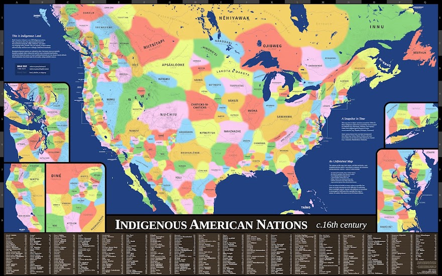
Indigenous American Nations, 16th century - 2024 edition
All downloads here are in the public domain and free of copyright, and may be reproduced and modified for any purpose. I encourage anyone to build upon the map and make it better.
Original Full-Color Map
- High-resolution JPG for web viewing. Mercator projection. (10mb, 5600x8900 pixels)
- Ultra-high-resolution JPG for large-format printing. Designed for wall maps around 300dpi. Mercator projection. (22mb, 9956x15822 pixels)
Simplified Map
- Vector PDF with simple boundary lines. Simplified territory boundaries designed for letter-size printed. Conic projection. (30mb)
NOTE: In reality, many traditional territories overlap each other without the need for strict land borders. These simplified lines are only used to improve readability.
Shapefiles, approximate boundaries
NOTE: For easier readability, these shapes have been simplified to avoid overlapping. But in reality, many areas of land have been shared by multiple Indigenous nations without hard borders.
- SHP files for use in GIS software. (ZIP file, 124kb)
- Google Earth and Google Maps files coming soon.
Indigenous American Nations, 16th century - 2022 edition
All downloads here are in the public domain and free of copyright, and may be reproduced and modified for any purpose. I encourage anyone to build upon the map and make it better.
Original Full-Color Map
- High-resolution JPG for web viewing. Mercator projection. (12mb, 5832x9332 pixels)
- Ultra-high-resolution JPG for large-format printing. Designed for 36 x 57½ inch wall map at 300dpi. Mercator projection. (25mb, 10800x17200 pixels)
Simplified Map
- Vector PDF with simple boundary lines. Simplified territory boundaries designed for letter-size printing. Equidistant conic projection. (3mb)
NOTE: In reality, many traditional territories overlap each other without the need for strict land borders. These simplified lines are only used to improve readability.
Shapefiles, approximate boundaries
NOTE: For easier readability, these shapes have been simplified to avoid overlapping. But in reality, many areas of land have been shared by multiple Indigenous nations without hard borders.
- SHP file for use in GIS software. (270kb)
- KML file for Google Earth. (670 kb)
- Approximate territory shapes in Google Maps.
Other Maps

- I created this Diné bizaad map of the bus routes in the Navajo Nation Transit system in 2019, in the style of a city metro map. It's most likely outdated now, but I'm still quite happy with how cool-looking it turned out.